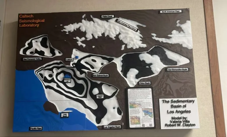
The sprawling metropolis of Los Angeles, long defined by its precarious relationship with the San Andreas and Puente Hills fault lines, now faces a more nuanced understanding of its seismic vulnerability. A newly developed, high-precision 3D model of the Los Angeles basin has provided geologists with an unprecedented view of the subterranean landscape, revealing that downtown Los Angeles sits atop as much as 6.2 miles (10 kilometers) of soft sediment. This thick, basin-fill layer acts as a geological amplifier, significantly increasing the duration and intensity of ground shaking during a seismic event. While the general phenomenon of basin amplification has long been understood by the scientific community, this updated map represents the most granular and comprehensive look at the region’s complex underground structure to date, offering critical data for urban planners, structural engineers, and emergency management officials.
The Geology of the LA Basin
The Los Angeles basin is a structural depression filled with a complex, deep accumulation of sedimentary deposits. Over millions of years, erosional forces have deposited layers of sand, silt, and clay that have settled into the bedrock troughs beneath the city. Unlike solid crystalline bedrock, which tends to transmit seismic waves rapidly, these loose sedimentary layers trap and amplify the energy radiating from an earthquake.
When seismic waves generated by a rupture encounter these deep basins, they become "trapped," bouncing back and forth within the sediment. This process, often referred to as the "bowl effect," causes the ground to shake longer and more violently than it would on firmer ground. The 3D model confirms that the depth of these sediments is uneven, creating a subterranean topography that dictates how different neighborhoods will experience the same earthquake. Downtown Los Angeles, due to its position over the deepest part of this sedimentary "bowl," is particularly susceptible to these prolonged, rolling motions.
A Chronology of Seismic Awareness
The history of earthquake science in Southern California has been one of incremental, yet vital, technological leaps. Following the catastrophic 1933 Long Beach earthquake, which resulted in the deaths of 115 people and caused widespread destruction, the state of California began to take seismic engineering seriously, leading to the enactment of the Field Act. This legislation mandated higher construction standards for schools, marking the beginning of modern seismic safety efforts.
Throughout the late 20th century, the 1971 San Fernando earthquake and the 1994 Northridge earthquake provided sobering case studies in how local geology influences damage patterns. After the Northridge event, researchers noted that certain neighborhoods experienced far more damage than others, even when they were equidistant from the epicenter. These discrepancies led to the development of the Southern California Seismic Network (SCSN) and early efforts to map the basin’s depth.
In the 2000s, the Southern California Earthquake Center (SCEC) began aggregating data from thousands of small, human-induced, and natural seismic events to build the "Community Velocity Model" (CVM). The recent 3D mapping update builds upon these foundational datasets, utilizing advanced computational power and high-resolution geophysical imaging to refine the structural boundaries of the basin with a precision that was impossible only a decade ago.
Data-Driven Insights: Why Precision Matters
The new model provides a vital shift from general regional risk assessments to site-specific seismic forecasting. Current data indicates that the basin’s depth ranges significantly, from shallow areas near the foothills to the extreme 10-kilometer depths in the urban core. By mapping these variations, scientists can now simulate "shake maps" that predict how ground motion will propagate through the city.
Supporting data from recent simulations suggests that in the event of a magnitude 7.0 earthquake on the Puente Hills fault—a blind-thrust fault that runs directly beneath the urban core—the sedimentary amplification could increase peak ground velocity by up to 50% in certain downtown corridors. This is a critical metric for engineers tasked with retrofitting older, non-ductile concrete buildings, which are historically the most vulnerable to the long-period ground motions associated with deep sedimentary basins.
Furthermore, the model integrates data from "passive imaging," a technique that uses the ambient seismic noise of the city—generated by traffic, trains, and ocean waves—to map the subterranean structure without the need for explosive testing. This provides a non-invasive, continuous stream of data that allows the model to remain accurate as urban development alters the surface landscape.
Official Responses and Scientific Consensus
Geologists and seismologists associated with the California Institute of Technology (Caltech) and the United States Geological Survey (USGS) have emphasized that while the findings are alarming, they are primarily a tool for mitigation. Dr. Lucy Jones, a leading seismologist who has long advocated for seismic resilience, has noted that the challenge for Los Angeles is not the earthquakes themselves, but the built environment’s response to them.
"We are moving past the era of ‘if’ and into the era of ‘how,’" one source familiar with the study suggested. "Knowing the depth of the basin doesn’t change the earthquake risk, but it fundamentally changes our building codes."
City officials have expressed interest in integrating these findings into the "Resilient LA" initiative, a long-term plan aimed at hardening city infrastructure. The ability to overlay geological data with population density maps allows the city to prioritize seismic retrofitting projects, focusing resources on areas where the risk of structural failure is mathematically highest.
Broader Implications for Urban Infrastructure
The implications of this 3D model extend far beyond building codes. Infrastructure such as water pipelines, fiber-optic networks, and power grids are also susceptible to ground deformation. During significant seismic events, the liquefaction of soft, sediment-rich soil can lead to the displacement of buried pipes, causing catastrophic utility failures that can last for weeks or months after the shaking stops.
The updated map also serves as a reminder of the "Big One" narrative that has long dominated California’s public discourse. However, experts are shifting the focus from a single, apocalyptic event toward a more systemic view of regional resilience. If scientists know which parts of the basin are most likely to amplify shaking, the city can implement more localized, effective warning systems.
For example, high-speed rail lines and automated transit systems can be programmed to trigger emergency braking if sensors in a deep basin detect the onset of high-amplitude, low-frequency waves. Similarly, emergency response staging areas can be identified in zones where the sediment is shallower, ensuring that critical facilities remain operational and accessible when the shaking subsides.
Future Directions in Seismic Research
The success of this 3D modeling project has paved the way for further research into the "basin edge effect." This phenomenon occurs when seismic waves traveling through deep sediment strike the harder rock of the basin’s edge, causing waves to reflect and focus energy into a narrow strip of ground. Research teams are now deploying dense arrays of seismic sensors along these edges to capture data that could further refine the city’s risk profile.
As urban density increases, the demand for high-rise residential and commercial space grows. The construction of these towers in the heart of the Los Angeles basin necessitates a deeper understanding of the interaction between foundation piles and the deep sedimentary fill. Engineers are now exploring base-isolation technologies specifically designed to decouple buildings from the types of slow, rolling, long-period waves generated by the deep basin structure.
In conclusion, the new 3D seismic model of the Los Angeles basin is more than just a scientific achievement; it is a vital tool for the survival of a modern megacity. By illuminating the hidden, shaky reality beneath the pavement, scientists have provided a roadmap for a more resilient future. While the geological reality of the Los Angeles basin remains a permanent factor, the city’s ability to adapt to these conditions will determine its long-term viability in one of the world’s most seismically active regions. As technology continues to bridge the gap between abstract geological theories and actionable urban planning, the focus remains clear: the ground may be shaky, but the foundation of our response must be solid.