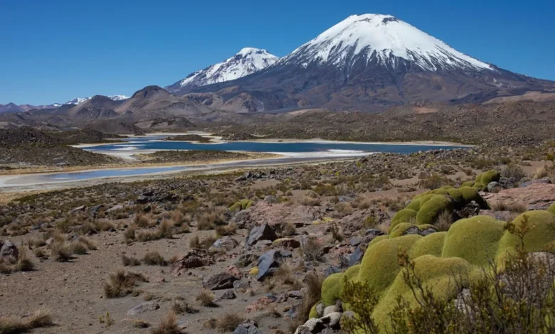
Twenty-two million years ago, a catastrophic volcanic event in what is now northern Chile acted as a geological time capsule, preserving a precise snapshot of the nascent Andes Mountains and challenging long-held assumptions regarding the pace of tectonic uplift. This massive eruption, originating from the Lauca Caldera, blanketed the high-altitude landscape in thick layers of ignimbrite—a hardened, pumice-rich rock formed from the rapid cooling of pyroclastic density currents. By studying these volcanic deposits, researchers have gained unprecedented clarity into the structural infancy of one of the world’s most formidable mountain chains.
The Mechanism of Preservation: A Geological Pompeii
The eruption in question produced a pyroclastic flow, a devastating mix of superheated volcanic gases, ash, and pulverized rock that cascades down mountain slopes with the velocity and destructive force of a molten tsunami. While the most famous historical parallel is the A.D. 79 eruption of Mount Vesuvius, which entombed the Roman city of Pompeii in a matter of hours, the Lauca Caldera event occurred on a scale that fundamentally reshaped the topography of the South American continent.
Unlike the Vesuvius event, which is studied primarily for its archaeological significance, the Lauca eruption serves as a stratigraphic benchmark for geologists. The ignimbrite sheets act as a "geological glue," sealing the underlying terrain and protecting fossilized flora, riverbeds, and early soil profiles from millions of years of erosion. This allows scientists to reconstruct the elevation and climate of the region during the Miocene epoch, providing a clear window into the environment that existed long before the Andes reached their current towering heights.
Chronology of Andean Orogeny
To understand the significance of the Lauca Caldera discovery, one must examine the broader timeline of Andean formation. The Andes are the product of the subduction of the Nazca Plate beneath the South American Plate, a process that has been active for tens of millions of years.
- Late Cretaceous to Early Paleogene (70–50 million years ago): The initial stages of crustal thickening begin, driven by the compression of the South American margin.
- The Miocene Epoch (23–5 million years ago): A period of intense tectonic activity. It was during the early Miocene, approximately 22 million years ago, that the Lauca eruption occurred.
- The Pliocene to Present (5 million years ago–today): Accelerated uplift leads to the extreme altitudes observed in the modern central Andes, with peaks exceeding 6,000 meters.
The discovery of the 22-million-year-old ignimbrite layer confirms that at this midpoint in the timeline, the Andes were already undergoing significant transformation, yet were still in a relatively early stage of their eventual vertical rise. The data suggests that the mountain range did not rise in a single, violent tectonic lurch but rather through a sustained, rhythmic process of uplift punctuated by massive volcanic activity.
Supporting Data and Geochemical Evidence
Geological surveys conducted in the Lauca region have utilized radiometric dating, specifically Argon-Argon (Ar/Ar) dating, to pinpoint the age of the ignimbrite deposits. These analyses reveal that the volcanic activity was not an isolated incident but part of a larger volcanic arc system that mirrored the movement of the subducting plates.
The thickness of the ignimbrite sheets provides a metric for the sheer magnitude of the eruption. In some sections of the northern Chilean altiplano, these layers exceed 100 meters in depth. This thickness is indicative of a "super-eruption," a classification reserved for events that eject more than 450 cubic kilometers of material into the atmosphere. The chemical signature of the rocks—specifically the ratio of strontium and neodymium isotopes—points to a crustal source that was already significantly thickened by the early Miocene, providing evidence that the crustal "root" of the Andes was well-established even 22 million years ago.
Scientific Implications and Expert Analysis
The implications of these findings are substantial for the field of plate tectonics. For decades, researchers debated whether the Andes rose rapidly due to "delamination"—a process where the dense base of the crust peels away and sinks into the mantle, causing the remaining crust to "bounce" upward—or through a slower, more gradual accumulation of material.
"The evidence preserved by the Lauca ignimbrite suggests a more nuanced, steady-state model of growth," notes Dr. Elena Vance, a lead researcher in Andean geodynamics. "While delamination events certainly occur, the snapshot we have from 22 million years ago suggests that the topography was shaped by a combination of consistent tectonic compression and frequent, high-volume volcanic episodes that acted as both a builder and a preservative force."
This analysis suggests that the Andes may have reached significant heights earlier than previously estimated, influencing regional climate patterns much sooner than climate models had initially predicted. By altering the landscape, the growing mountain range created rain shadows, forcing the evolution of unique ecosystems on the eastern and western slopes of the continent.
The Broader Impact on Regional Topography
The preservation of this landscape has allowed geologists to map ancient river networks that existed before the current drainage basins were fully formed. These rivers were eventually dammed or diverted by the massive ignimbrite flows, creating transient lakes that further altered the geological record.
Furthermore, the study of the Lauca Caldera has practical applications in modern resource management. The same volcanic processes that created the ignimbrite layers are often associated with the deposition of valuable minerals. The Central Andes represent one of the world’s most significant hubs for copper and lithium mining. Understanding the timing and intensity of these ancient volcanic events helps mining geologists predict the distribution of mineralized ore bodies, which are often trapped in the structural traps formed by ancient volcanic collapses.
A Legacy of Fire and Stone
The study of the Lauca Caldera is a testament to the power of geological serendipity. What was once a day of unimaginable destruction for the prehistoric life of the region has become a fundamental data point for modern science. By looking back 22 million years, researchers are able to strip away the current veneer of the Andes to see the inner workings of the Earth’s crust.
As tectonic research continues to advance, the narrative of the Andes remains one of the most compelling stories in planetary science. The mountains are not merely static piles of rock; they are dynamic, evolving structures that respond to the heat of the mantle and the pressure of the plates. The eruption at Lauca Caldera provides the essential evidence needed to bridge the gap between theoretical tectonic models and the observable reality of the mountain range as it exists today.
In conclusion, the 22-million-year-old volcanic snapshot has solidified our understanding of the Andean cycle. It serves as a reminder that the dramatic peaks currently dominating the South American skyline are the result of a slow, laborious, and often violent process of crustal construction—a process that continues to unfold in the deep, unseen layers of the Earth beneath our feet. Through the lens of the Lauca ignimbrite, the history of the Andes is no longer a matter of conjecture, but a clearly defined sequence of geological milestones that continue to shape the world we inhabit.