
Google-Backed FireSat Satellites Launch Amid Worsening Wildfire Crisis, Promising Enhanced Early Detection

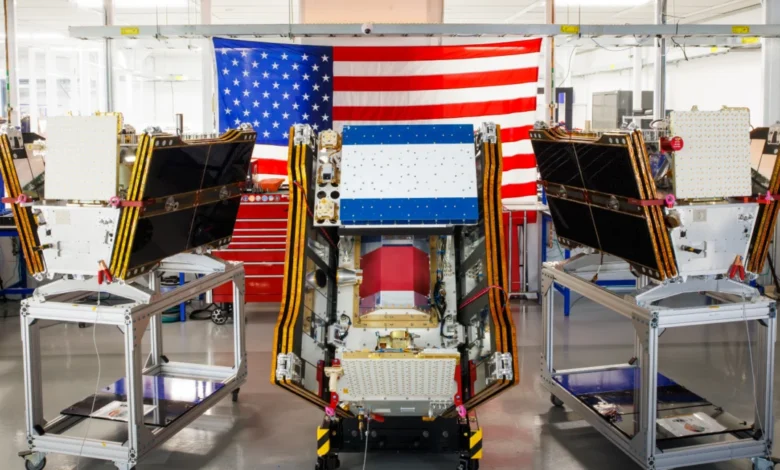
As unprecedented wildfire activity blankets vast swathes of Canada and the United States in a pall of smoke, the first three operational satellites of the Google-backed FireSat program have successfully launched into orbit. This pivotal deployment, marking a significant stride in global wildfire detection capabilities, heralds a new era for fire management, promising to identify even nascent blazes across the United States, Australia, and Europe before the close of the year.
The launch, executed on July 7, 2026, aboard a SpaceX Falcon 9 rocket from Vandenberg Space Force Base in California, signifies a crucial transition to "initial operational capability" for the FireSat constellation. This ambitious project, spearheaded by the non-profit Earth Fire Alliance, aims to revolutionize wildfire monitoring. Following a rigorous three-month testing period, these initial three satellites will commence actively supplying critical data to fire agencies, ensuring comprehensive coverage of every fire-prone region on Earth at least twice daily.
A New Frontier in Wildfire Surveillance
FireSat distinguishes itself as the world’s first satellite constellation specifically engineered for wildfire detection. Its design is optimized to spot smaller fires that frequently elude the observational capabilities of existing satellite systems. The advanced microsatellites were meticulously developed by California-based satellite manufacturer Muon Space, benefiting from substantial financial backing. Google has committed over $15 million towards the initial deployment, underscoring its strategic investment in climate resilience technology. Complementing this, the Bezos Earth Fund has pledged a significant $26 million, highlighting a growing philanthropic interest in combating the global wildfire challenge.
Each FireSat satellite is equipped with cutting-edge multispectral imaging technology, designed to penetrate dense smoke plumes and cloud cover. This allows for the detection of fires as minuscule as five by five meters—approximately 16 by 16 feet. The efficacy of this groundbreaking capability was rigorously demonstrated by a FireSat Protoflight satellite, which was launched in March 2025. This prototype successfully collected over one million images, proving its ability to identify low-intensity blazes that remained invisible to conventional satellites. This breakthrough is critical, as early detection dramatically increases the chances of containing fires before they escalate into uncontrollable infernos.
Chronology of a Vision: From Concept to Orbit

The FireSat program represents years of development and collaboration, moving from conceptualization to tangible operational assets:
- September 2024: Google publicly announces its backing of the privately funded FireSat constellation, highlighting its commitment to leveraging technology for environmental challenges.
- March 2025: The FireSat Protoflight satellite launches, serving as a critical testbed for the constellation’s advanced imaging technology. Over the ensuing months, it successfully demonstrates the ability to detect small, low-intensity fires through smoke and clouds, validating the core technology.
- June 2025: The Protoflight satellite provides crucial imagery of the Nipigon 6 fire in Ontario, Canada, showcasing its capacity to identify active fire regions, burn scars, and aid in situational awareness for ground crews.
- July 7, 2026: The first three operational FireSat satellites are successfully launched aboard a SpaceX Falcon 9 rocket from Vandenberg Space Force Base, California, marking the transition to "initial operational capability."
- July 2026 – September 2026: A three-month in-orbit testing and calibration phase commences for the newly launched satellites.
- Late 2026: Data provision begins for "early adopter" organizations, including fire agencies in California, Colorado, Australia, and Portugal, integrating FireSat data into their wildfire management protocols.
- By 2029: The FireSat program aims to expand its constellation to provide hourly imagery coverage across the entire globe, significantly enhancing real-time monitoring.
- Early 2030s: The full constellation, projected to comprise over 50 satellites, is expected to be in orbit, delivering imagery with an unprecedented 20-minute revisit rate, offering near real-time insights into wildfire dynamics.
Anticipated Impact and Early Adopters
The potential benefits of detecting small wildfires before they rage out of control are profound. The Earth Fire Alliance has released compelling projections, estimating that even an hourly revisit rate from the FireSat constellation could lead to significant savings:
- Economic Impact: Over $1 billion in avoided fire damage costs. This figure underscores the immense financial burden wildfires impose on communities, infrastructure, and economies.
- Environmental Impact: Prevention of nearly 22 million tons of carbon emissions. Wildfires are major contributors to greenhouse gas emissions, exacerbating climate change in a destructive feedback loop.
- Humanitarian Impact: Protection of an estimated 3,500 homes and 1.3 million acres of land. This highlights the direct benefit to human safety and biodiversity.
A select group of "early adopter" organizations is poised to integrate FireSat data into their operational workflows by the end of this year. These include fire agencies in regions highly susceptible to wildfires: California and Colorado in the United States, as well as national and regional fire services in Australia and Portugal. These agencies will be at the forefront of leveraging this advanced satellite imagery to inform their response strategies, resource allocation, and preventative measures.
The Role of AI and Google’s Commitment
Google Research plays a critical role in maximizing the utility of FireSat data. The company plans to deploy its sophisticated AI models to analyze the operational FireSat data, comparing it with extensive historical images. This AI-driven analysis is designed to accurately identify even the most nascent fires and to inform predictive modeling of wildfire behavior, trajectories, and potential escalation. Google has lauded the launch of the first operational FireSat satellites as "another tangible step forward in putting practical AI to work for climate resilience," reflecting its broader strategy to apply artificial intelligence to pressing global challenges.
The Paradox of Progress: AI’s Energy Footprint

While Silicon Valley’s rapid development and deployment of advanced AI models offer promising solutions for climate resilience, this technological surge is not without its own environmental implications. The exponential growth of larger AI data centers necessitates massive quantities of electricity. Alarmingly, this demand is frequently met by the development of new natural gas projects in the United States, a trend that could collectively contribute to over 129 million tons of greenhouse gas emissions annually.
Google itself has acknowledged the formidable challenge of sourcing sufficient clean energy projects to offset the burgeoning emissions from its energy-hungry data centers. The company’s internal reports reveal a significant increase in its electricity usage, which grew by 37 percent in 2025 alone, largely driven by its aggressive AI buildout. This presents a complex paradox: while AI offers powerful tools for climate mitigation, its underlying infrastructure demands a substantial energy commitment, often from fossil fuel sources, thus potentially contributing to the very climate change it aims to combat. This inherent tension underscores the need for sustainable AI development practices and accelerated investment in renewable energy infrastructure.
The Global Wildfire Crisis: A Symptom of Climate Change
The FireSat program’s launch comes at a time when the world grapples with an intensifying wildfire crisis, starkly illustrated by the infernos currently ravaging Canada’s boreal forests. These blazes, which began spreading this summer, have forced thousands of residents, particularly from First Nations communities, to evacuate their homes, disrupting lives and livelihoods. Beyond immediate destruction, these wildfires have generated immense smoke clouds that have drifted across vast regions, inflicting hazardous air pollution upon over 100 million people in Canadian and US cities, from the Midwest to the Mid-Atlantic and Northeast.
The increasing size, intensity, and frequency of wildfires, particularly in vulnerable ecosystems like Canada’s boreal forests, are directly attributable to climate change. Rising global temperatures, prolonged droughts, and altered weather patterns, driven by greenhouse gas emissions from human reliance on fossil fuels, create ideal conditions for fires to ignite and spread uncontrollably. Canada has experienced two of its most destructive wildfire seasons in 2023 and 2025, with the last three fire seasons ranking among the ten worst on record.
Werner Kurz, a retired senior research scientist at Natural Resources Canada, succinctly captured the gravity of the situation in an interview with The Atlantic: "What is unfolding is what climate and forest scientists have been predicting for 30 years. That as the world gets hotter and drier, we are exposing forests to more and more risk, and the old strategies of fire suppression are simply being overwhelmed."
Challenges in Traditional Fire Management

Traditional fire suppression methods, while essential, are proving increasingly inadequate against the backdrop of climate-fueled wildfires. Fighting fires in remote, often uninhabited, forest regions necessitates specialized resources such as fixed-wing air tankers capable of dropping fire retardants and heavy-lift helicopters for transporting firefighting crews and equipment to remote sites. However, the burden of acquiring and maintaining such expensive firefighting aircraft typically falls on individual Canadian provinces and US states. In recent years, every available aircraft has often been deployed, straining resources to their limits. Recognizing this critical shortfall, the Canadian government took a significant step this year by leasing 10 new aerial firefighting aircraft and two support assets, making them available as surge capacity for provinces.
As of July 17, the Canadian Wildland Fire Information System reported nearly 900 active wildfires across the country, with over 3,600 fires recorded year-to-date, having consumed more than 6.6 million acres. A sobering reality is that dozens of these wildland fires are currently classified as "out of control" and are merely being monitored rather than actively suppressed. This difficult decision reflects the stark reality faced by fire agencies: managing limited resources, prioritizing human lives, and assessing the risks to firefighters in extremely dangerous conditions.
Beyond Detection: A Holistic Approach to Wildfire Resilience
While Google’s financial and technical support for AI-powered wildfire detection represents a crucial advancement, it is imperative to recognize that detection is but one element within a multi-faceted approach to preventing blazes from spiraling out of control. Effective wildfire management requires a comprehensive strategy that also includes:
- Sufficient Resources: Fire agencies need adequate funding and personnel to manage ecosystems proactively.
- Prescribed Burns: Implementing controlled burns is a vital tool for reducing fuel loads, restoring ecological balance, and preventing mega-fires.
- Rapid Suppression: Equipping and empowering firefighters to quickly contain unwanted fires once detected.
- Community Preparedness: Educating and preparing communities in fire-prone areas.
Ultimately, the job of fire agencies has become exponentially more challenging due to the pervasive influence of global warming. The FireSat constellation offers a powerful new lens through which to view and respond to wildfires, providing an unprecedented level of early detection and situational awareness. However, its full potential can only be realized when integrated into a broader strategy that addresses the underlying causes of the wildfire crisis—climate change—and bolsters the human and material resources dedicated to land management and fire suppression. The future of wildfire resilience hinges on a synergistic blend of cutting-edge technology, robust policy, and sustained commitment to environmental stewardship.